I am an associate professor at School of Geospatial Engineering and Science, Sun Yat-sen University. My research focuses on 3D information acquisition and applications, including UAV photogrammetry and LiDAR, flight path planning, 3D reconstruction, bathymetry, underwater terrain mapping, spatial and point cloud analysis.
I got my Doctor of Engineering degree from College of Surveying and Geo-informatics, Tongji University in 2020, under the supervision of Prof. Chun Liu. During 2018-2019, I worked as a joint PhD student at Institute for Photogrammetry, University of Stuttgart under the supervision of Prof. Dr.-Ing. Norbert Haala.
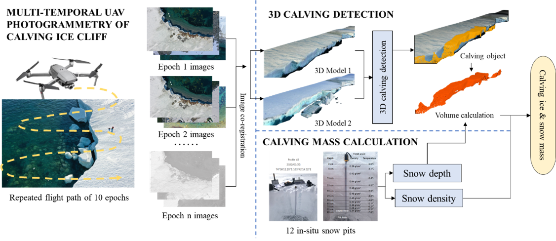
I joined in Following Arctic/Antarctic iCE 2024 and 2025 (FACE2024 & 2025) Expedition aboard the RV Zhong Shan Da Xue Ji Di (“中山大学极地”号) in summer 2024 & 2025 as a member of the scientific research team, leading UAV remote sensing and flight testing for polar research.
🎓 Education
- 2014- 2020, DEng. in Surveying and Mapping, College of Surveying and Geo-informatics, Tongji University, Shanghai, China
- 2018 - 2019, Joint Ph.D. Student, Institute for Photogrammetry, University of Stuttgart, Germany
- 2010- 2014, B.Sc. in Geographic Information System, College of Surveying and Geo-informatics, Tongji University, Shanghai, China
💼 Experience
- 2025- Present, Associate Professor, School of Geospatial Engineering and Science, Sun Yat-sen University, Zhuhai, China
- 2020 - 2025, Assistant Professor, School of Geospatial Engineering and Science, Sun Yat-sen University, Zhuhai, China
📝 Publications
(*Corresponding Author)
Shuhang Zhang, Lei Zheng*, Huizhou Zhou, Qiuyang Zhao, Jie Li, Yinyue Xia, Wuming Zhang, Xiao Cheng
- International Journal of Applied Earth Observation and Geoinformation, 142, 104620. (SCI, Q1)
Shuhang Zhang, Chun Liu*, Norbert Haala
- International Journal of Applied Earth Observation and Geoinformation (JAG), 127, 103667. (SCI, Q1)
Jinchen He, Shuhang Zhang*, Wei Feng, Xiaodong Cui, Min Zhong
- Remote Sensing of Environment, 318, 114614 (SCI, Q1)
-
He, J., Zhang, S.*, Cui, X., et al. (2024). Remote sensing for shallow bathymetry: A systematic review. Earth-Science Reviews, 104957.
-
He, J., Zhang, S.*, Feng, W., et al. (2024). Quantifying earthquake-induced bathymetric changes in a tufa lake using high-resolution remote sensing data. International Journal of Applied Earth Observation and Geoinformation, 127, 103680.
-
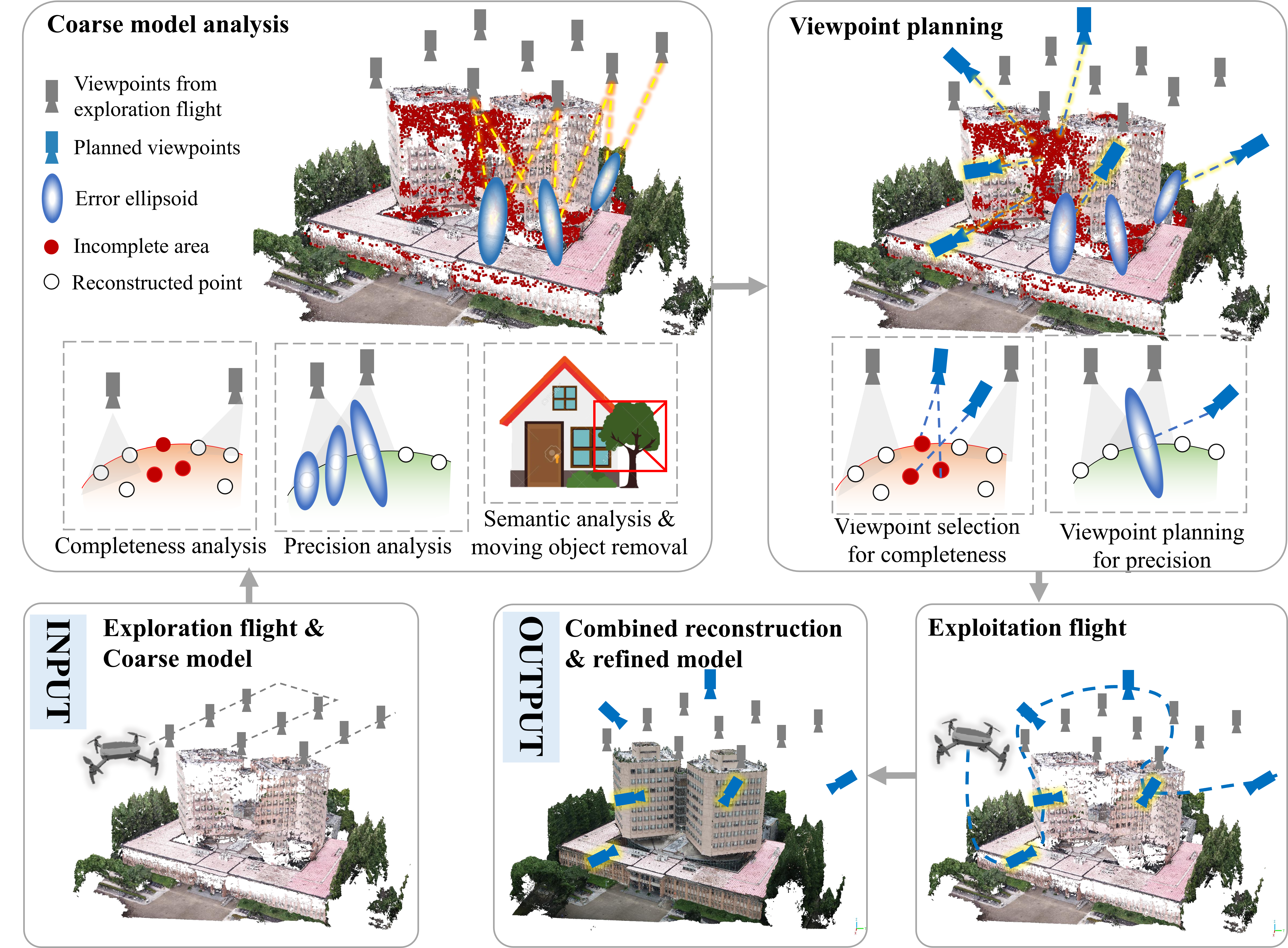
Zhang, S., Zhang, W., & Liu, C. (2023). Model-Based Multi-UAV Path Planning for High-Quality 3D Reconstruction of Buildings. The International Archives of the Photogrammetry, Remote Sensing and Spatial Information Sciences, 48, 1923-1928.
-
Cai, S., Zhang, S.*, Zhang, W., et al. (2023). A General and Effective Method for Wall and Protrusion Separation from Facade Point Clouds. Journal of Remote Sensing, 3, 0069.
-
Pan, D., Shao, J., Zhang, S.*, et al. (2023). SLAM-based Forest Plot Mapping by Integrating IMU and Self-calibrated Dual 3D Laser Scanners. IEEE Transactions on Geoscience and Remote Sensing.
-
Zhang, S., Liu, C.*, & Haala, N. (2020). Three-dimensional path planning of UAVs imaging for complete photogrammetric reconstruction. ISPRS Annals of the Photogrammetry, Remote Sensing and Spatial Information Sciences, V-1-2020, 325–331.
-
Liu, C., Zhang, S.*, & Akbar, A. (2019). Ground Feature Oriented Path Planning for Unmanned Aerial Vehicle Mapping. IEEE Journal of Selected Topics in Applied Earth Observations and Remote Sensing, 12(4), 1175-1187.
-
Zhang, S., Liu, C.*, & Zhou, Y. (2019). UAV-Based Gigapixel Panoramic Image Acquisition Planning with Ray Casting-Based Overlap Constraints. Journal of Sensors.
🌟 Fundings and Projects
-
2024.01 – 2025.12. Key Laboratory Stable Support Project, State Administration of Science, Technology and Industry for National Defense. Rapid orthophoto generation ***. Role: PI. Funding: CNY 300,000.
-
2023.12 – 2027.11. National Key R&D Program of China (14th Five-Year Plan). *** for polar remote sensing. Role: Sub-task Lead. Funding: CNY 1,000,000. (国家重点研发计划子课题负责人)
-
2023.08 – 2023.12. MOE Key Laboratory of Polar Environment Stereo Observation and Application. Rapid acquisition of low-altitude shipborne UAV orthophotos in polar regions. Role: PI. Funding: CNY 100,000. (教育部极地环境立体观测与应用重点实验室开放基金)
-
2022.06 – 2023.03. Zhuhai Institute of Surveying and Mapping. Data acquisition and processing using UAV LiDAR and oblique photogrammetry for offshore islands. Role: PI. Funding: CNY 100,000. (珠海市测绘院项目)
-
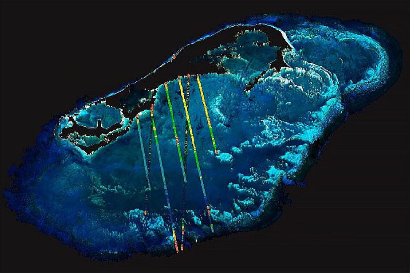
2023.07 – 2025.04. Key Laboratory of Marine Environment Survey Technology and Application, MNR (Open Fund). High-fidelity 3D reconstruction of underwater coral reefs from UAV imagery. Role: PI. Funding: CNY 30,000. (海洋环境调查技术与应用重点实验室开放基金)
🏆 Honors and Awards
- 2024, Outstanding Teaching Achievement Award, 12th National University GIS Forum (6/7)
- 2020, Outstanding Graduate, Shanghai Municipal Government
- 2019, Second Prize of Science and Technology Progress Award, Ministry of Education (14/15)
💬 Talks and Presentations
- 2025.10, “RGB-Assisted Orthoimage Mosaicking of Thermal Infrared Sea Ice Imagery from Low-Cost UAVs”, The Eighth International Symposium on Arctic Research
- 2025.10, “Mapping the drifting sea ice with UAV photogrammetry”, 2025 IEEE/RSJ International Conference on Intelligent Robots and Systems (IROS), Workshop – Towards Resilient Navigation in the Wild
- 2024.12, “Polar Scientific Research UAV Optical and Infrared Applications”, 7th National Marine Optics Technology Exchange Conference
- 2024.10, “Arctic Ship-based UAV Remote Sensing: Status and Prospects”, CAE Academic Symposium on Continental Shelf and Regional Institutional Science and Technology Frontiers
- 2023.12, “UAV Fine Terrain Survey of Wudalianchi Aerial Gravity Gradient Calibration Field”, 1st Guangdong-Hong Kong-Macao Greater Bay Area Surveying and Remote Sensing Conference
- 2023.09, “Model-Based Multi-UAV Path Planning for High-Quality 3D Reconstruction of Buildings”, The ISPRS Geospatial Week 2023 (poster)
- 2023.05, “UAV 3D Path Planning for Fine Visual Reconstruction of Buildings”, 18th China Geographic Information Science Theory and Method Academic Conference
- 2021.11, “UAV 3D Path Planning for Fine Visual Reconstruction”, 2021 UAV Industry Innovation Application Conference Urban Space 3D Modeling Forum
- 2020.08, “Three-dimensional path planning of UAVs imaging for complete photogrammetric reconstruction”, XXIV ISPRS Congress Virtual Event